|
While researching the people buried in the two cemeteries, I learned about some named locations in the area that you could call "obscure". There may be nothing at the locations anymore, but the names were important in the past, and were mentioned in official records and/or newspapers.
Click the map to show it by itself in your browser.
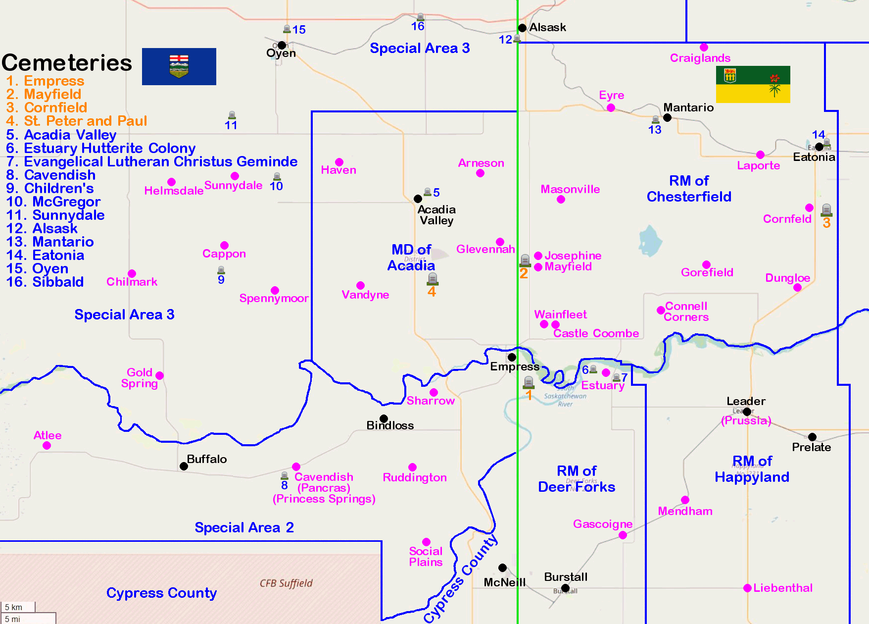
CGNDB = Canadian Geographical Names Database
Post Offices and Postmasters: 1851 - 1981
Map = Alberta Homestead Maps - circa 1918 (Courtesy of the University of Lethbridge)
|
| Arneson, AB | 51.1866667, -110.075 | CGNDB | | Map 64A (page 7) |
| Atlee, AB | 50.8416667, -110.9502778 | CGNDB | Post Office, 1914-1963 | Wikipedia |
| Cappon, AB | 51.1008333, -110.6030556 | CGNDB | Post Office, 1912-1968 | Wikipedia |
| Castle Coombe Post Office, SK | 50.997862, -109.928411 | Post Office, 1913-1927 | | |
| Cavendish, AB (aka Pancras, Princess Springs) | 50.8155556, -110.4552778 | CGNDB | Wikipedia | Map #54A (page 7) |
| Chilmark Post Office, AB | 51.063149, -110.789954 | Post Office, 1915-1928 | | |
| Connell Corners Post Office, SK | 51.016265, -109.713341 | Post Office, 1918-1930 | | |
| Cornfeld Post Office, SK | 51.147155, -109.411037 | Post Office, 1913-1921 | | |
| Craiglands Post Office, SK | 51.351069, -109.625331 | Post Office, 1911-1945 | | |
| Dungloe Post Office, SK | 51.045319, -109.434323 | Post Office, 1912-1918 | | |
| Estuary, SK | 50.93539, -109.8183 | CGNDB | Post Office, 1912-1970 | Wikipedia |
| Eyre, SK | 51.273589, -109.815156 | CGNDB | Post Office, 1914-1963 | Wikipedia |
| Gascoigne, SK | 50.727698, -109.790377 | CGNDB | Wikipedia | |
| Glevennah Post Office, AB | 51.103135, -110.040035 | Post Office, 1913-1918 | | |
| Gold Spring Post Office, AB | 50.932307, -110.731955 | Post Office, 1913-1933 | | |
| Gorefield Post Office, AB | 51.074433, -109.620367 | Post Office, 1910-1930 | | |
| Haven Post Office, AB | 51.205015, -110.365587 | Post Office, 1922-1953 | | |
| Helmsdale Post Office, AB | 51.179541, -110.708559 | Post Office, 1913-1962 | | |
| Josephine Post Office, SK | 51.085089, -109.963459 | Post Office, 1914-1932 | | |
| Laporte, SK | 51.2145526, -109.5103943 | CGNDB | Post Office, 1914-? | Wikipedia |
| Liebenthal, SK | 50.659622, -109.536428 | CGNDB | Post Office, 1940-? | Wikipedia |
| Majestic, AB | 50.825, -110.8333333 | CGNDB | Wikipedia | |
| Masonville Post Office, SK | 51.158148, -109.916957 | Post Office, 1916-1922 | | |
| Mayfield School, SK | 51.067320, -109.957997 | School, 1914-? | | |
| Mendham, SK | 50.7722722, -109.6642639 | CGNDB | Post Office, 1921- | Wikipedia |
| Prussia, SK (now Leader, SK) | 50.8889827, -109.5419457 | CGNDB | Wikipedia |
| Ruddington, AB | 50.815823, -110.218357 | | | Map #53A (page 5) |
| Sharrow, AB | 50.9122222, -110.1766667 | CGNDB | | Map #53A (page 5) |
| Social Plains, AB | 50.733333, -110.18333 | CGNDB | | Map #53 (page 4) |
| Social Plains School, AB | 50.7173138, -110.1900169 | 1913-1949, Now is the Social Plains Community Hall |
| Spennymoor Post Office, AB | 51.041212, -110.499245 | Post Office, 1914-1929 | | |
| Sunnydale Post Office, AB | 51.186784, -110.580660 | Post Office, 1912-1962 | | |
| Vandyne, AB | 51.048531, -110.324843 | CGNDB | Post Office, 1912-1930 | Map #64 (page 6) |
| Wainfleet School, SK | 50.997765, -109.951626 | School, 1924-1959? | | |
 |
The Bruce's Graveyards group of websites are not monatized,
meaning I do not make any money from these websites.
There are no advertisements.
Bruce A. Johnson -
Empress, Alberta, Canada |
Do you have any corrections,
concerns, questions, or comments?
I'd happy to discuss them. |
|